Heatwaves create summer of extremes
Credit: Copernicus ECMWF.
WMO – Intense heat continued to grip large parts of the Northern Hemisphere in this summer of extremes. New daily and station temperature records have been broken and it is possible that some national records may fall. The World Meteorological Organization (WMO) will examine any potential new continental temperature records as the heatwave continues.
June saw the warmest global average temperature on record, which continued into July, according to preliminary figures.
“The extreme weather – an increasingly frequent occurrence in our warming climate – is having a major impact on human health, ecosystems, economies, agriculture, energy and water supplies. This underlines the increasing urgency of cutting greenhouse gas emissions as quickly and as deeply as possible,” said WMO Secretary-General Prof. Petteri Taalas.
“In addition, we have to step up efforts to help society adapt to what is, unfortunately, becoming the new normal. The WMO community is providing forecasts and warnings to protect lives and livelihoods as we strive to achieve our goal of Early Warnings for All,” said Taalas.
Meanwhile, heavy precipitation has caused devastating floods and loss of life in some countries, including South Korea, Japan and the northeast United States.
Heatwaves are amongst the deadliest natural hazards with thousands of people dying from heat-related causes each year, said WMO experts.
Large parts of North Africa, the Mediterranean, Asia and the southern U.S. have been hit by parallel and stationary heat domes causing subsidence and trapping heat at the surface.
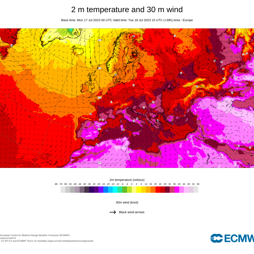
In Europe, both minimum and maximum temperatures were record-high in some locations, including in mountain regions.
“It is thought that Europe is currently experiencing the peak of this heatwave, with parts of Greece, eastern Spain, Sardinia, Sicily and southern Italy seeing temperatures above 45 degrees Celsius at the start of this week,” said the Copernicus news website.
The heat was forecast to continue in late July in central and eastern Mediterranean basin countries. National meteorological and hydrological services of France, Italy, Greece, Bosnia Herzegovina, Croatia, Montenegro, North-Macedonia, Serbia issued orange and red alerts for high-temperatures on July 20 and 21. The weekly forecast suggests above-normal temperatures higher than three degrees during next week mainly in parts of eastern Mediterranean and northern Africa.
Sea surface temperatures (SSTs) of the Mediterranean Sea will be exceptionally high over the coming days and weeks, exceeding 30 C in some parts, and more than four degrees above average in a large part of the western Mediterranean. In some parts of central and northern Europe below-average temperatures and rain is expected.
The impacts of marine heatwaves impacts include the migration of species and extinctions, the arrival of invasive species with consequences for fisheries and aquaculture.
There is no immediate respite in sight. A further continuation into August is possible, said a Climate Watch Advisory issued by the WMO’s Regional Climate Centre for Europe.
“An increasing number of studies demonstrate connections between rapid warming and the Arctic and mid-latitude weather patterns, including in atmospheric dynamics such as the jet stream. The jet stream becomes weaker and wavier when warm air is transported to the north and cold air to the south. In these conditions, near-stationary weather patterns establish and lead to prolonged heatwaves and drought in some regions and heavy precipitation in others,” said Alvaro Silva, an expert with the WMO climate services division.
A widespread heatwave is intensifying in the U.S., with high temperatures likely in numerous places, according to the U.S. National Weather Service (NWS), which says a few locations could even register their all-time temperature records.
On the weekend of July 15 to 16, excessive heat warnings and advisories covered more than 100 million people with “dangerous and swelting heat” especially across much of the western U.S.
Areas at risk in the southwest include California, southern Nevada and Arizona. In the south-central and southeast U.S., maximum heat index values could near or exceed 43 C. Many parts of Florida, including Miami, have been hit by an extended, record-breaking heatwave.
Phoenix has suffered an extended streak of temperatures above 37.8 C. That was expected to continue, with daytime maximum temperatures of at least 46.7 C until July 21 and overnight low temperatures of more than 32.2 C, according to the NWS. Phoenix has had nine straight days with overnight low temperatures at or above 34.4 C.
“We need to broaden focus beyond maximum temperatures because the minimum temperature is most important for health and critical infastructure,” said WMO extreme heat senior advisor John Nairn.
A temperature sensor at Furnace Creek in Death Valley National Park in California recorded 53.3 C on July 16.
According to the WMO Archive of Weather and Climate Extremes, the hottest temperature ever recorded was in Furnace Creek, Death Valley, California at 56.7 C on July 10, 1913.
“Unusually warm waters in the Gulf of Mexico and in the western Atlantic Ocean will contribute to persistent, oppressive humidity in nearly coastal areas and limit nighttime cooling,” said the National Weather Service.
Overnight minimum temperatures are expected to reach new highs, and this will increase the risk of health-related impacts.
In Canada, record-breaking wildfires continue to burn big forest areas. More than 500 wildfires were out of control as of July 11. According to the Canadian Interagency Forest Fire Centre, more than nine million hectares already burnt in 2023 – compared to the 10-year average of about 800,000 hectares.
Sanbao weather station in Turpan city in China’s Xinjiang province, had a temperature of 52.2 C on July 16, setting a new national temperature record according to a report by the China Meteorological Administration.
“The exceptionally high temperatures in subtropical regions constitute the prime meteorological origin of the extended heat wave over the Mediterranean. The signature of the ongoing El Niño and climate change in the extent of this event, needs more data and analysis,” said Dr. Omar Baddour, chief of climate monitoring at WMO.
Heavy rains and flooding caused severe damage and loss of life in several parts of the world.
Forty people were reported killed as torrential rain and flash floods hit the Republic of Korea on July 14 and floods in Northwest China killed a reported 15 people.
In northern India, roads and bridges collapsed and houses were swept away as rivers overflowed during heavy monsoonal rainfall and flooding which killed dozens of people. The mountainous state of Himachal Pradesh was badly hit, as were the regions of Punjab, Rajastan and Uttar Pradesh. New Delhi reportedly marked its wettest July day in 40 years, with 153 millimeters of rain falling in one day.
The Japanese Meteorological Agency (JMA) issued heavy rain emergency warnings on Monday for the Fukuoka and Oita prefectures, on Kyushu, the country’s third largest island. A new daily rainfall record of 376.0 mm fell on July 10 at Minousan and 361.5 mm at Hikosan, both in the Kyushu region.
“It’s raining like never before,” said JMA.
In the northeastern U.S., parts of New England faced yet more torrential rainfall on saturated soils following serious floods at the start of July. New York issued a flash flood emergency and more than four million people were under flood alerts on July 11.
“As the planet warms, the expectation is that we will see more and more intense, more frequent, more severe rainfall events, leading also to more severe flooding,” said Stefan Uhlenbrook, Director of hydrology, water and cryosphere at WMO.
“Developed countries like Japan are extremely alert, and they’re also very well prepared when it comes to flood management measures. But many low-income countries have no warnings in place, hardly any flood defense structures and no integrated flood management. WMO is committed to improving the situation,” he said.


