Parade of storms to resume in Northwest after devastating floods, mudslides
By weather
| 3 min read
AccuWeather – Another train of storms is expected to race through the hard-hit areas of the Pacific Northwest in the United States as well as British Columbia this week.
Thousands of residents have been displaced, forced to ration gas and left stranded due to destroyed roadways after a powerful atmospheric river created a once-in-500-year flood event that devastated parts of Washington state as well as B.C. last week. At least five total fatalities were reported across the United States and Canada as rescuers search through the rubble that was caused by over 254 millimetres of rain in places.
The weekend ended quietly across the region, but the tranquil weather is not expected to last long. AccuWeather forecasters are tracking multiple rounds of wet weather that could impact some of the same areas as last week.
The first storm will arrive across the Pacific Northwest later in the day on Monday then slide into the Intermountain West by Tuesday. Rainfall will likely arrive along the coast and in the western portions of the region, including Seattle and Vancouver.
By Monday night, rain is forecast to reach places like Portland and Medford, Oregon, along with areas farther inland, like Spokane, Wash., and Kamloops, B.C. On Tuesday, this storm will likely combine with another area of low pressure from the southwestern U.S. to bring snow and flurries to some of the Rocky Mountains, including Calgary and Missoula, Montana.
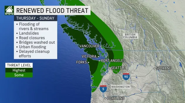
Forecasters predict the second round will be the one to really watch out for. This storm will unload heavy rain that could produce flooding and increase the risk of mudslides in the region.
“Multiple waves of moisture will lead to excessive rainfall in the Pacific Northwest later this week into this weekend,” said AccuWeather Storm Warning Meteorologist Dana Carron. The storm could cause road closures and urban flooding.
For those in the U.S., Thanksgiving will be a particularly wet holiday as several inches of rain could fall across western and northwestern Washington.
The Canadian side of the border might face the worst or more widespread impacts and particularly where flooding has already occurred. Mayor Henry Braun of Abbotsford, B.C. extended the flooding state of emergency to Nov. 29 as the city rushes to rebuild the dike ahead of the coming storms.
“Our fingers are crossed,” said the mayor, according to the Canadian Broadcasting Corporation.
Twenty-five to 50 millimetres of rain will be likely in Seattle, Wash. and Vancouver, B.C. from Wednesday evening to Friday evening, local time. Beyond rainfall, another key element in how potentially dangerous this event could be is the warmth associated with it.
“Higher temperatures accompanying these systems will lead to snowmelt in the Washington Cascades and the Canadian Rockies which will further intensify the potential for flooding,” said Carron. This is expected to enhance the flooding of rivers and streams. If rivers or streams swell high enough, they could wash out roadways or even bridges, as was the case last week.
AccuWeather meteorologists deemed the areas with the highest potential for flooding will be across the Olympic Peninsula, Vancouver Island, the northern Cascades and areas of the Coast Mountains from the U.S. border to Terrace, B.C.
After this heavy rain event, warmer conditions will return next week, which could continue to melt snow across the mountains and worsen flooding issues.


